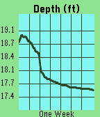
This app pulls gage height from river monitoring locations tracked by USGS. It then plots the last week of data, scaling automatically to your screen. The ID will default to a location near downtown Iowa City, IA. However, you can update the ID in the settings page at any time and the graph will update once you press save. Units can also be selected between feet and meters.

DISCLAIMER : This app contains code generated by Gemini. The vast majority of which is in the index.js file.