TopoNav brings offline-style topographic maps and GPX path guidance to your Pebble smartwatch. It streams live OpenTopoMap tiles from your smartphone companion, rendering detailed contour lines, hiking trails, and rivers in Pebble-native 64 colors (GColor8).
Whether you are hiking, walking, or exploring new paths, TopoNav keeps you oriented without needing to pull out your phone.
Key Features:
🗺️ Topographic Map Tiles: Real-time rendering of elevation contours and walking trails.
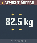
🥾 On-Watch Route Manager: Swap, start, or deactivate GPX routes directly from a dedicated on-watch menu.
📍 Sensor-Fused Compass Chevron: Real-time direction arrow using the watch's magnetic compass when standing, and switching to GPS-course when walking to filter out wrist-swing jitter.
⏺️ Activity Recorder: Long-press the Select button on your watch to record your walk. View metrics and download the standard .gpx file from the settings webview.
📊 Dual-Column Stats Dashboard: Check average speed, distance (walked / remaining), elevation profile (gain / loss), and coordinates at a glance.
🔊 Vibration Alerts: Stay on track with haptic turn-by-turn prompts and warnings if you drift more than 50 meters off-route.
🔋 High Contrast UI: High-legibility status bars and an integrated watch battery percentage.
Requirements: Requires a persistent connection to your phone's Pebble app with GPS and Internet access enabled.
Built as an interactive Vibe-Coding project! 🎸✨
 4
4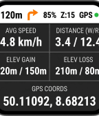 14
14