WikiRadius
atomlabor

Watchapp
Description
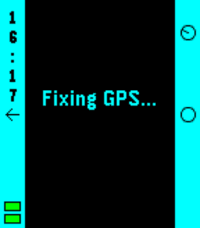
Whether you are a tourist exploring a new city or a local wanting to uncover the hidden history of your hometown:
WikiRadius turns every simple walk into an interactive journey of discovery.

The app uses your smartphone’s high-precision GPS to scan your current coordinates and automatically delivers fascinating facts about landmarks, historical sites, and geographical features right to your wrist. No manual searching required, just start walking, and the world around you begins to "speak".

How the Smart 3-Stage Radar Works
WikiRadius isn't a normal browser; it's a pure "location-to-information" bridge. To always show you the most relevant destination, an intelligent search logic works in the background in three stages:

Local Area (200m): The app primarily searches for major, relevant Wikipedia articles in your immediate vicinity.

Monument Scanner (200m): If there is no Wikipedia entry, WikiRadius taps into OpenStreetMap, explicitly searching for hidden historical monuments or structures (historic).

Wide-Angle Radar (1km): If your direct surroundings are completely empty, the app automatically expands its search radius to 1,000 meters to find the next major destination for you.

Display Symbols Explained
So you know exactly what the radar has locked onto at a glance, WikiRadius uses special visual indicators in the headline:

No Prefix (e.g., Space Needle): A classic Wikipedia article in your immediate vicinity (under 200m).

The [H] Symbol (e.g., [H] Old Water Tower): A historical monument, building, or relic found via the OpenStreetMap scanner.

The Double Arrow >> (e.g., >> Golden Gate Bridge): A destination from the wide-angle radar. It is further away (up to 1km) but serves as an excellent long-distance goal for your walk. Once you cross the 200m mark, the arrow disappears.

Key Features
Live Navigation Cockpit: A smooth real-time compass and dynamic distance display guide you to your discovery, meter by meter.

Smart Feedback: Your watch vibrates subtly only when a new destination appears on the radar. No annoying continuous vibrations while navigating.


Universal Compatibility: Flawlessly supports all Pebble models (Emery, Basalt, Chalk, Diorite, Aplite, Gabbro...), adapting its UI perfectly to round, rectangular, color, and monochrome screens.

Independent Integration: WikiRadius retrieves public data from the Wikipedia API and Overpass API to deliver high-quality knowledge. However, the app is not affiliated with, endorsed by, or connected to the Wikimedia Foundation or OpenStreetMap. It acts purely as an independent, location-based client.

Discover what you would have otherwise just walked right past.

Best https://atomlabor.de
- Developeratomlabor
- CategoryTools & Utilities
- PlatformsOG Pebble, Steel, Time/Time Steel, Time Round, 2, 2 Duo, Time 2, Round 2
- Updated2026-04-25
- Version3.4