Satellite Overpass
Daniel Bally
Watchapp
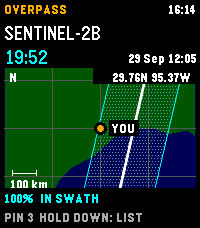
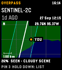
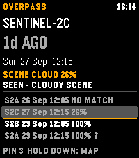
Description
Plan Landsat 8/9 and Sentinel-2A/B/C passes over your location on Pebble Time 2. See a countdown, hourly cloud forecast, and modeled cross-track coverage. A 30-day history reports matching Earth Search scenes, whole-scene cloud cover, product-lag status, or a catalogue no-match. No-match does not prove that no acquisition occurred.

The regional map shows your center, selected ground track, and nominal imaging swath; predictions and maps are cached for offline use. The map is an overview, unavailable above 80° latitude, and not live navigation. Sentinel-2A has a partial acquisition plan. Coverage and swath-edge status are geometric heuristics, not probabilities or guarantees. Cloud forecasts over five days have little skill.

Refresh sends current coordinates to Open-Meteo for cloud forecasts and Element 84 Earth Search for scene history. Pin records stay in phone storage and are not included in those requests; open app settings to copy them as GeoJSON. Requires location permission for fresh local predictions and an internet connection for forecasts and scene history.

Controls: UP/DOWN selects a pass; hold DOWN switches map/list; SELECT saves a timestamped pin; hold SELECT refreshes. Data: CelesTrak, Open-Meteo (CC BY 4.0), Element 84 Earth Search, Natural Earth (public domain). Source: https://github.com/globe-and-atlas/overpass-watch
- DeveloperDaniel Bally
- CategoryTools & Utilities
- PlatformsTime 2
- Updated2026-09-28
- Version0.3.3