Should I Fly?
Brooman Inks

Watchapp
Description
Should I Fly?
A Pebble watchapp for drone pilots in the United States. Open it before a flight and get a one-glance GO, CAUTION or NO-GO verdict, based on wind at flying altitudes, weather, and FAA airspace restrictions around you.

Works on Pebble Time 2 (emery) and Pebble Round 2 (gabbro).

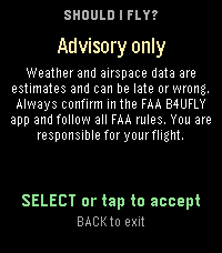
Advisory only. This app is a convenience, not an authority. Data can be late, incomplete, or wrong. Always confirm in the FAA's B4UFLY app or another official source, and follow all FAA rules (Part 107 or recreational flyer rules) before you fly.

Screens
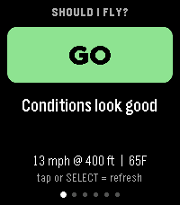
Use UP and DOWN (or swipe on the touchscreen) to move between pages. SELECT, or a tap on the touchscreen, refreshes.

Verdict: GO, CAUTION or NO-GO and the most important reason
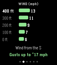
Wind: wind speed at 0, 100, 200, 300 and 400 ft, wind direction, estimated gusts
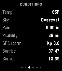
Conditions: temperature, sky, rain, visibility, GPS storm (Kp) index, sunrise and sunset
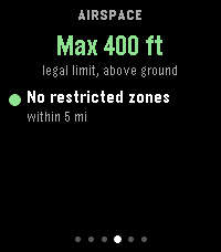
Airspace: FAA ceiling at your spot, and nearby zones with distance and direction
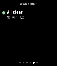
Warnings: every reason not to fly, worst first
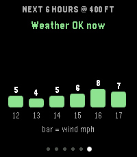
Next 6 hours: wind at your max altitude each hour, color coded, with the best time to fly
The watch vibrates when the verdict is CAUTION or NO-GO (this can be turned off), and can play a sound (off by default, see Sounds). The 6-hour chart covers weather only, not airspace.

What it checks
Wind and gusts at 0, 100, 200, 300 and 400 ft
Temperature, with cold-battery and heat warnings
Rain, snow, thunderstorms and visibility (3 mile minimum for line of sight)
Geomagnetic storms (Kp index), which can disturb GPS
Night and twilight (anti-collision light reminder)
Temporary Flight Restrictions (TFRs), including VIP, security, hazard and air show TFRs
Controlled airspace (Class B, C, D and surface Class E) and the FAA UAS Facility Map ceiling for your exact location
Prohibited and Restricted areas
Military and national security UAS restrictions
Stadiums (restricted during events)
Zones within 5 miles (adjustable), with distance and compass direction
How the verdict works
These are the default limits. All of them can be changed in Settings.

CAUTION when any of these is true:

Wind at 400 ft is 15 mph or more
Gusts (estimated at 400 ft) are 20 mph or more
Temperature is 40 F or below, or 95 F or above
Visibility is under 3 miles
There is light rain or drizzle
Kp index is 5 or more
The FAA grid ceiling is under 400 ft, you are in controlled airspace, a TFR or restricted zone is within 1 mile, or you are inside a stadium zone
It is night
Airspace data could not be fully loaded
NO-GO when any of these is true:

Wind at 400 ft is 24 mph or more
Gusts are 30 mph or more
Temperature is 14 F or below, or 104 F or above
Visibility is under 1 mile
There is measurable rain or a thunderstorm
Kp index is 7 or more
You are inside a TFR, a Prohibited or Restricted area, or a military restriction zone
The FAA grid ceiling is 0 ft
Settings
Open the app's settings from the Pebble phone app (tap the app, then the gear). Everything is optional.

Units: wind in mph, knots, m/s or km/h; temperature in F or C; distance and altitude in feet and miles, or meters and kilometers
Flight: max flight altitude (100 to 500 ft, default 400), airspace search radius (1 to 10 miles, default 5), night-flight warning on or off, stadium warning on or off
Wind limits: caution and no-go values for wind and for gusts
Temperature limits: cold and hot caution and no-go values
Visibility and GPS: visibility caution and no-go values, Kp index caution and no-go values
Alerts: vibration on or off, sound on or off, volume
Limits are entered in mph, F, miles and feet, whatever units you display. The wind screen shows five rows from 0 up to your max altitude.

Sounds
Turn on Play sounds in Settings. Each time new data arrives the watch plays one of three sounds:

GO: a bright rising chime (four notes going up)
CAUTION: a soft two-tone descending sound (triangle wave)
NO-GO: a low buzzer (three square-wave bursts)
Sounds follow the watch's own mute and Quiet Time settings. Both emery and gabbro have a speaker.

Data sources (all free, no API keys)
Weather and winds: Open-Meteo (open-meteo.com)
Space weather: NOAA Space Weather Prediction Center (swpc.noaa.gov)
UAS Facility Map, Class airspace, Special Use Airspace, military restrictions, stadiums: FAA public ArcGIS services
TFRs: FAA TFR service (tfr.faa.gov)
Your location is sent only to these services to look up conditions. Nothing is stored or sent anywhere else.

Install
Open this link in CloudPebble to import and build: https://cloudpebble.repebble.com/ide/import/github/brooks2564/Pebble-Should-I-Fly

Or build locally with "pebble build" and install with "pebble install --phone ".

The app needs location permission on your phone (Pebble app settings).

Limitations
US only. Airspace data covers the United States.
Weather models report wind at 10 m, 80 m, 120 m and 180 m only. The 0 ft value is the 10 m (33 ft) wind, and the other rows are interpolated between those heights.
Gusts are an estimate: the 10 m gust excess is added to the wind at your max altitude.
Wind and weather come from forecast models, not a sensor at your location.
National parks, state parks, and local rules are not checked. Many ban drones.
Part-time restrictions and some TFRs may change faster than the data refreshes.
Project layout
src/c/main.c: watch UI (6 pages, buttons, swipe and tap, vibration and sound)
src/pkjs/index.js: phone side (location, data fetching, airspace math, units, verdict)
src/pkjs/config.json: settings page definition (Clay)
tools/make_assets.py: generates the store banner, icons and menu icon
screenshots: store banner and icons, plus screenshots/emery and screenshots/gabbro with one image per app page
Author: Brooman Inks
- DeveloperBrooman Inks
- CategoryTools & Utilities
- PlatformsTime 2, Round 2
- Updated2026-10-31
- Version1.1.0